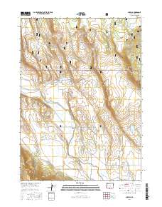
2017 Map of Lorella
USGS Topo · Published 2017About this map
Lorella sits at the base of the rising southern Oregon highlands, where the irrigation-rich valley floor meets the timbered slopes of the Fremont National Forest. The landscape is defined by its water management infrastructure, featuring a complex network of man-made waterways including the High-Line Ditch, Low Line Ditch, and Lorella Lateral that support the local agricultural economy. These ditches divert water from the Lost River, which meanders through the central terrain, crossed by the Keller Bridge. High above the valley, the topography rises sharply toward prominent landmarks like Goodlow Mtn and Dead Indian Hill. Scattered reservoirs, such as Olive Reservoir and Mahoney Reservoir, dot the northern forest, illustrating the historical and ongoing efforts to capture and control water in this Klamath County ranching and farming corridor.
Find a feature on this map
44 named features on this map. Tap any name to fly to it.
Don’t see what you’re looking for? This feature index may not catch every label — zoom into the map to look around manually.
Map Details
Editions of this 2017 Lorella Map
This is the sole edition of this map. No revisions or reprints were ever made.
Other maps of this area

1889 · Klamath
USGS Topo · 1:250,000

1894 · Klamath
USGS Topo · 1:250,000

1955 · Klamath Falls
USGS Topo · 1:250,000

1957 · Malin
USGS Topo · 1:62,500

1958 · Klamath Falls
USGS Topo · 1:250,000

1960 · Gerber Reservoir
USGS Topo · 1:62,500

1960 · Bly
USGS Topo · 1:62,500

1960 · Beatty
USGS Topo · 1:62,500
1988 · Bryant Mountain
USGS Topo · 1:24,000
1988 · Malin
USGS Topo · 1:24,000