
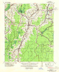
1939 Map of Lorenzen
USGS Topo · Published 1941About this map
The town of Rolling Fork serves as the central hub for this Delta landscape, where the Yazoo and Mississippi Valley and Illinois Central railroads intersect. This 1930s survey reveals a region defined by its complex hydrology and agricultural drainage, with a network of bayous like Mound Bayou and Tillman Bayou feeding into Deer Creek. Settlement patterns follow these natural levees and rail lines closely, with established communities at Anguilla, Cary, and Egremont. Notable landmarks include Mont Helena and an Indian Mound near Grace, indicating deep historical layers of human habitation. To the east, the Big Sunflower River winds through the bottomlands, creating features such as Cypress Bend and Buck Point, while the western portion is dominated by the expansive Poindexter Island between Steele Bayou and the main channel flows.
Find a feature on this map
51 named features on this map. Tap any name to fly to it.
Don’t see what you’re looking for? This feature index may not catch every label — zoom into the map to look around manually.
Map Details
Editions of this 1939 Lorenzen Map
2 editions found
Other maps of this area

1909 · Wilsons Point
USGS Topo · 1:24,000

1913 · Wilson Point
USGS Topo · 1:31,680

1939 · Onward
USGS Topo · 1:62,500

1939 · Readland
USGS Topo · 1:62,500

1939 · Alsatia
USGS Topo · 1:62,500

1939 · Mayersville
USGS Topo · 1:62,500

1939 · Swan Lake
USGS Topo · 1:62,500

1940 · Auter
USGS Topo · 1:62,500

1940 · Mechanicsburg
USGS Topo · 1:62,500

1953 · Greenwood
USGS Topo · 1:250,000