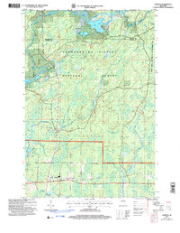
2005 Map of Loretta
USGS Topo · Published 2006About this map
The Chippewa River East Fork meanders through this portion of the Chequamegon Nicolet National Forest, defining a landscape of wetlands and water bodies. The small settlements of Loretta and Draper serve as the primary human anchors in this forest-dominated region, with the Tuscobia Trail following a former rail grade through both towns. This trail, along with the Dead Horse Trail Parking area, highlights the region's transition into a recreational landscape by the early 2000s. Water is central to the area's geography, with the Chippewa River flowing through the northern reaches near Bear Lake and Cub Lake. A crossing of the Great Divide appears in the southern portion, marking the significant hydrologic boundary that shapes the drainage patterns of Fishtrap Creek and the Thornapple River.
Find a feature on this map
26 named features on this map. Tap any name to fly to it.
Don’t see what you’re looking for? This feature index may not catch every label — zoom into the map to look around manually.
Map Details
Editions of this 2005 Loretta Map
This is the sole edition of this map. No revisions or reprints were ever made.
Other maps of this area

1941 · Kennedy
USGS Topo · 1:48,000

1942 · Glidden
USGS Topo · 1:48,000

1942 · Clam Lake
USGS Topo · 1:48,000

1944 · Draper
USGS Topo · 1:48,000

1945 · Kennedy
USGS Topo · 1:48,000

1945 · Clam Lake
USGS Topo · 1:48,000

1945 · Glidden
USGS Topo · 1:48,000

1947 · Draper
USGS Topo · 1:48,000

1953 · Ashland
USGS Topo · 1:250,000

1953 · Rice Lake
USGS Topo · 1:250,000