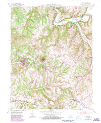
1953 Map of Loretto
USGS Topo · Published 1987About this map
Sisters of Loretto Convent stands as a central landmark in this mid-century portrait of Marion and Nelson Counties, anchoring the community of Nerinx. The landscape is defined by the winding course of the Beech Fork and the intricate drainage of Pottinger Creek and Hardins Creek. This survey captures a rural Kentucky Catholic heartland, where parish life and education are evidenced by Holy Cross Ch, St Mark Ch, and St Francis High Sch.
Find a feature on this map
39 named features on this map. Tap any name to fly to it.
Don’t see what you’re looking for? This feature index may not catch every label — zoom into the map to look around manually.
Map Details
Editions of this 1953 Loretto Map
3 editions found
Other maps of this area

1949 · Cravens
USGS Topo · 1:24,000

1949 · Shepherdsville
USGS Topo · 1:62,500

1953 · Howardstown
USGS Topo · 1:24,000

1953 · Loretto
USGS Topo · 1:24,000

1953 · Maud
USGS Topo · 1:24,000

1953 · Saint Catharine
USGS Topo · 1:24,000

1953 · Bardstown
USGS Topo · 1:24,000

1953 · New Haven
USGS Topo · 1:24,000

1953 · Raywick
USGS Topo · 1:24,000

1953 · Lebanon West
USGS Topo · 1:24,000