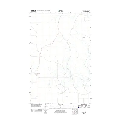
2011 Map of Loring
USGS Topo · Published 2011About this map
Loring serves as the primary hub of this northern Phillips County landscape, situated along the intersection of local routes and the northern reach of highway infrastructure. The settlement is anchored by local essential services, including the Loring Post Office and the Phillips Co Vol Fire Company Loring Sta, reflecting the importance of this small community center in the vast Montana plains. Outside the town center, the terrain is defined by a sparse network of drainage and water management, including the uniquely named Not Much Dam and the winding course of Whitewater Creek in the northeastern corner. Roads like Sunny Slope Rd provide access through the grid-patterned sections, illustrating the balance between open ranchland and the structured townships that define the region's agricultural and rural character.
Find a feature on this map
6 named features on this map. Tap any name to fly to it.
Don’t see what you’re looking for? This feature index may not catch every label — zoom into the map to look around manually.
Map Details
Editions of this 2011 Loring Map
This is the sole edition of this map. No revisions or reprints were ever made.
Other maps of this area

1920 · Cowan
USGS Topo · 1:125,000

1954 · Glasgow
USGS Topo · 1:250,000

1957 · Glasgow
USGS Topo · 1:250,000

1958 · Glasgow
USGS Topo · 1:250,000

1968 · Austin Lake
USGS Topo · 1:24,000

1984 · Austin Coulee
USGS Topo · 1:24,000

1984 · Whitewater West
USGS Topo · 1:24,000

1984 · Morgan
USGS Topo · 1:24,000
1984 · Loring NW
USGS Topo · 1:24,000
1984 · Martin Lake
USGS Topo · 1:24,000