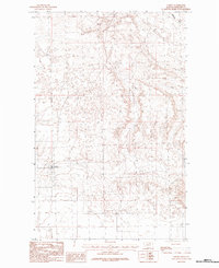
1984 Map of Loring
USGS Topo · Published 1984About this map
Loring serves as the focal point of this northern Montana landscape, situated in the vast prairie lands of Phillips County during the mid-1980s. The settlement's layout and surrounding section lines reflect the late 20th-century agricultural and ranching patterns of the region. To the northeast, the drainage of Whitewater Creek cuts through the terrain, providing a distinct geographic contrast to the surrounding high plains. As a provisional map, this sheet captures the essential topography and rural infrastructure of the area exactly as it was documented during late-1970s field checks, preserving the location of local benchmarks and transport routes through this portion of the Milk River valley hinterlands.
Find a feature on this map
2 named features on this map. Tap any name to fly to it.
Don’t see what you’re looking for? This feature index may not catch every label — zoom into the map to look around manually.
Map Details
Editions of this 1984 Loring Map
This is the sole edition of this map. No revisions or reprints were ever made.
Other maps of this area

1920 · Cowan
USGS Topo · 1:125,000

1954 · Glasgow
USGS Topo · 1:250,000

1957 · Glasgow
USGS Topo · 1:250,000

1958 · Glasgow
USGS Topo · 1:250,000

1968 · Austin Lake
USGS Topo · 1:24,000

1984 · Austin Coulee
USGS Topo · 1:24,000

1984 · Whitewater West
USGS Topo · 1:24,000

1984 · Morgan
USGS Topo · 1:24,000
1984 · Loring NW
USGS Topo · 1:24,000
1984 · Martin Lake
USGS Topo · 1:24,000