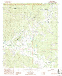
1986 Map of Lorman
USGS Topo · Published 1986About this map
Lorman stands at the center of this 1986 survey of Jefferson and Claiborne counties, a landscape defined by the winding course of the Natchez Trace Parkway and the deep incisions of the North Fork Coles Creek. The settlement pattern reflects the area's agricultural and transportation history, with small communities like Shankstown and Coon Box linked by old road networks and the Illinois Central Gulf Railroad.
Find a feature on this map
21 named features on this map. Tap any name to fly to it.
Don’t see what you’re looking for? This feature index may not catch every label — zoom into the map to look around manually.
Map Details
Editions of this 1986 Lorman Map
This is the sole edition of this map. No revisions or reprints were ever made.
Other maps of this area

1909 · Lake Bruen
USGS Topo · 1:24,000

1939 · Lorman
USGS Topo · 1:62,500

1953 · Natchez
USGS Topo · 1:250,000

1956 · Natchez
USGS Topo · 1:250,000

1958 · St. Joseph
USGS Topo · 1:62,500

1959 · Natchez
USGS Topo · 1:250,000

1962 · Fayette
USGS Topo · 1:62,500

1963 · Port Gibson
USGS Topo · 1:24,000

1963 · Red Lick
USGS Topo · 1:24,000

1963 · Union Church
USGS Topo · 1:62,500