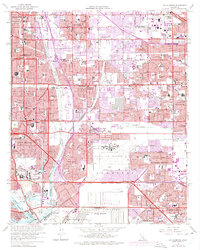
1964 Map of Los Alamitos
USGS Topo · Published 1975About this map
Naval Air Station Los Alamitos and the expansive U S Naval Weapons Station Seal Beach dominate the southern portion of this mid-1960s landscape, reflecting the heavy military and defense presence in suburban Orange County. The map captures a moment of intense urbanization as the border between Los Angeles and Orange Counties fills with post-war residential tracts and industrial corridors. Major infrastructure projects like the San Diego Freeway and the San Gabriel River channel provide the framework for burgeoning communities like Lakewood, Rossmoor, and Cypress. Educational and institutional growth is evident in the sprawling Calif State College at Long Beach and the presence of the U S Veterans Hospital. In the north, the transition from the older dairying heritage of Dairy Valley to suburban residential blocks is almost complete, though the Artesia Cemetery and numerous parish schools like St Josephs Sch remain as local landmarks.
Find a feature on this map
113 named features on this map. Tap any name to fly to it.
Don’t see what you’re looking for? This feature index may not catch every label — zoom into the map to look around manually.
Map Details
Editions of this 1964 Los Alamitos Map
4 editions found
Other maps of this area

1896 · Santa Ana
USGS Topo · 1:62,500

1896 · Anaheim
USGS Topo · 1:62,500

1896 · Las Bolsas
USGS Topo · 1:62,500

1896 · Downey
USGS Topo · 1:62,500

1898 · Anaheim
USGS Topo · 1:62,500

1899 · Downey
USGS Topo · 1:62,500

1901 · Southern California Sheet No. 1
USGS Topo · 1:250,000

1901 · Santa Ana
USGS Topo · 1:62,500

1901 · Anaheim
USGS Topo · 1:62,500

1902 · Downey
USGS Topo · 1:62,500