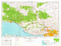
1959 Map of Los Angeles
USGS Topo · Published 1959About this map
Los Angeles and its northern suburban reaches are depicted at a pivotal mid-century moment, showing the rapid expansion of the San Fernando Valley and the coastal corridor toward Santa Barbara. The landscape is dominated by the massive protected lands of the Los Padres National Forest and Angeles National Forest, which separate the coastal basins from the Mojave Desert and the Cuyama Valley. Information-gain insights include the concentration of aerospace and defense infrastructure during the Cold War era, evidenced by the Point Mugu Air Missile Test Ctr and Port Hueneme USN. Transportation networks are in transition, with the Pacific Electric lines still visible alongside the growing highway system including Us 101 and Us 99. The map also captures several rural schools like the Castaic School and mining sites like the Monte Cristo Mines tucked into the mountain ranges.
Find a feature on this map
135 named features on this map. Tap any name to fly to it.
Don’t see what you’re looking for? This feature index may not catch every label — zoom into the map to look around manually.
Map Details
Editions of this 1959 Los Angeles Map
3 editions found

Other maps of this area

1894 · Los Angeles
USGS Topo · 1:62,500

1894 · Pomona
USGS Topo · 1:62,500

1896 · Pasadena
USGS Topo · 1:62,500

1896 · Anaheim
USGS Topo · 1:62,500

1896 · Redondo
USGS Topo · 1:62,500

1896 · Santa Monica
USGS Topo · 1:62,500

1896 · Downey
USGS Topo · 1:62,500

1897 · Pomona
USGS Topo · 1:62,500

1898 · Pomona
USGS Topo · 1:62,500

1898 · Santa Monica
USGS Topo · 1:62,500