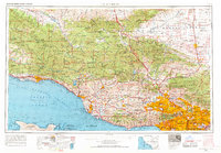
1959 Map of Los Angeles
USGS Topo · Published 1969About this map
Los Angeles and its sprawling suburban corridors anchor the southeastern corner of this regional survey, capturing the mid-century expansion of Southern California. The urban density of the San Fernando Valley and the Santa Monica Mountains coastline contrasts sharply with the expansive wildlands to the north. Immense tracts of the Los Padres National Forest and Angeles National Forest dominate the interior, punctuated by critical environmental landmarks like the Sisquoc Condor Sanctuary and the Sespe Game Refuge.
Find a feature on this map
177 named features on this map. Tap any name to fly to it.
Don’t see what you’re looking for? This feature index may not catch every label — zoom into the map to look around manually.
Map Details
Editions of this 1959 Los Angeles Map
3 editions found

Other maps of this area

1894 · Los Angeles
USGS Topo · 1:62,500

1894 · Pomona
USGS Topo · 1:62,500

1896 · Pasadena
USGS Topo · 1:62,500

1896 · Anaheim
USGS Topo · 1:62,500

1896 · Redondo
USGS Topo · 1:62,500

1896 · Santa Monica
USGS Topo · 1:62,500

1896 · Downey
USGS Topo · 1:62,500

1897 · Pomona
USGS Topo · 1:62,500

1898 · Pomona
USGS Topo · 1:62,500

1898 · Santa Monica
USGS Topo · 1:62,500