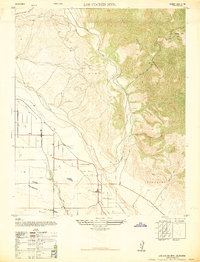
1947 Map of Los Coches Mtn
USGS Topo · Published 1947About this map
The confluence of the Santa Maria River and the Cuyama River marks a sharp transition from the valley floor to the high ridges of the San Rafael Mountains. Surveyed just after the war, this sheet documents the agricultural landscape surrounding Garey, where the Garey School and a Dismantled Railroad serve as quiet indicators of the area's early 20th-century development. While the western section shows the organized grids of the Suey land grant and the settlement at Muscio, the eastern terrain rises steeply toward Los Coches Mtn. and the winding Cañada de los Coches. This military edition, reprinted for civil use, preserves the details of family-named locales like Fugler Point and the transition of the local infrastructure along the Sisquoc-Garey Rd before later hydraulic changes altered the river basins.
Find a feature on this map
16 named features on this map. Tap any name to fly to it.
Don’t see what you’re looking for? This feature index may not catch every label — zoom into the map to look around manually.
Map Details
Editions of this 1947 Los Coches Mtn Map
This is the sole edition of this map. No revisions or reprints were ever made.
Other maps of this area

1905 · Lompoc
USGS Topo · 1:125,000

1922 · Nipomo
USGS Topo · 1:62,500

1937 · Branch Mtn
USGS Topo · 1:48,000

1942 · Lompoc
USGS Topo · 1:125,000

1942 · Santa Maria
USGS Topo · 1:62,500

1942 · Branch Mountain
USGS Topo · 1:62,500

1942 · Tepusquet Peak
USGS Topo · 1:62,500

1943 · Tepusquet Peak
USGS Topo · 1:62,500

1943 · Lompoc
USGS Topo · 1:125,000

1947 · Careaga Canyon
USGS Topo · 1:24,000