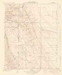
1934 Map of Los Viejos Hills
USGS Topo · Published 1934About this map
The Kettleman Hills dominate this portion of Kings County, revealing a landscape defined by industrial and agricultural transition during the early 1930s. The topographic data, surveyed just years after significant oil discoveries in the region, focuses on the Middle Dome and the complex network of drainage arroyos like Arroyo del Paso and Arroyo Culebrino that carve through the hills. Small settlements and staging points such as Los Medanos, El Collado, and La Esquadilla appear as quiet clusters along the transport corridors of the Hanford Road and Paso Robles Highway. The intricate contouring illustrates the transition from the steep ridges of Bullwheel Ridge and Broken Hill down to the broad, flat expanse of the La Rambla plain, where the arid geography meets the developing infrastructure of the San Joaquin Valley.
Find a feature on this map
38 named features on this map. Tap any name to fly to it.
Don’t see what you’re looking for? This feature index may not catch every label — zoom into the map to look around manually.
Map Details
Editions of this 1934 Los Viejos Hills Map
3 editions found
Other maps of this area

1912 · Coalinga
USGS Topo · 1:125,000

1914 · Lost Hills
USGS Topo · 1:125,000

1914 · Cholame
USGS Topo · 1:125,000

1915 · Cholame
USGS Topo · 1:125,000

1917 · Cholame
USGS Topo · 1:125,000

1930 · Discovery Well
USGS Topo · 1:31,680

1930 · Avenal Gap
USGS Topo · 1:31,680

1930 · Kettleman Plain
USGS Topo · 1:31,680

1930 · Middle Dome
USGS Topo · 1:31,680

1932 · Dudley Ridge
USGS Topo · 1:31,680