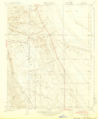
1934 Map of Los Viejos Hills
USGS Topo · Published 1943About this map
Kettleman Hills topography dominates this 1930s survey of the Central Valley edge, revealing a landscape defined by seasonal drainages and prominent ridges before intensive industrial development. The terrain is marked by a complex series of Spanish-named features such as La Llanura, La Bajada, and La Safida, indicating the historical cultural influence on local geographic naming. Hanford Road serves as the primary corridor through this arid country, winding past Mustang Hill and Bullwheel Ridge. The presence of the Middle Dome and various arroyos like Arroyo Culebrino illustrates the natural drainage patterns of the La Caballette region. This map is particularly useful for those studying the physical evolution of Kings County or tracing early 20th-century transportation routes through Pepper Grass Valley.
Find a feature on this map
34 named features on this map. Tap any name to fly to it.
Don’t see what you’re looking for? This feature index may not catch every label — zoom into the map to look around manually.
Map Details
Editions of this 1934 Los Viejos Hills Map
3 editions found
Other maps of this area

1912 · Coalinga
USGS Topo · 1:125,000

1914 · Lost Hills
USGS Topo · 1:125,000

1914 · Cholame
USGS Topo · 1:125,000

1915 · Cholame
USGS Topo · 1:125,000

1917 · Cholame
USGS Topo · 1:125,000

1930 · Discovery Well
USGS Topo · 1:31,680

1930 · Avenal Gap
USGS Topo · 1:31,680

1930 · Kettleman Plain
USGS Topo · 1:31,680

1930 · Middle Dome
USGS Topo · 1:31,680

1932 · Dudley Ridge
USGS Topo · 1:31,680