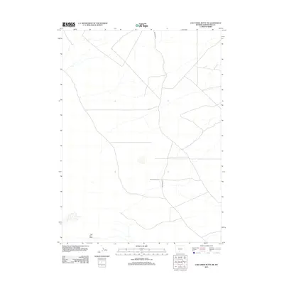
2012 Map of Lost Creek Butte SW
USGS Topo · Published 2012About this map
Rasmussen Sheep Camp serves as a lone human landmark in this high-desert stretch of Sweetwater County. The map reveals the essential desert infrastructure of the early twenty-first century, dominated by a web of service roads and tracks across the sagebrush-covered plains. The terrain is defined by drainage patterns like Red Wash Draw, which illustrates the intermittent water flow characteristic of the Great Divide Basin. Aside from the sheep camp, the landscape is primarily navigated via Red Desert Rd, showing a region dedicated to livestock grazing and resource access rather than permanent urban settlement. The sparse placement of these features emphasizes the isolation and specialized land use of this Wyoming interior during this era.
Find a feature on this map
3 named features on this map. Tap any name to fly to it.
Don’t see what you’re looking for? This feature index may not catch every label — zoom into the map to look around manually.
Map Details
Editions of this 2012 Lost Creek Butte SW Map
This is the sole edition of this map. No revisions or reprints were ever made.
Other maps of this area

1954 · Rock Springs
USGS Topo · 1:250,000

1958 · Rock Springs
USGS Topo · 1:250,000

1960 · Red Lake
USGS Topo · 1:62,500

1960 · Lost Creek Butte
USGS Topo · 1:62,500

1962 · Rock Springs
USGS Topo · 1:250,000

1970 · Red Desert NW
USGS Topo · 1:24,000

1970 · Tipton
USGS Topo · 1:24,000
1970 · Red Desert
USGS Topo · 1:24,000
1980 · Red Desert Basin
USGS Topo · 1:100,000
1988 · Red Lake NE
USGS Topo · 1:24,000