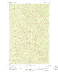
1963 Map of Lost Horse Mountain
USGS Topo · Published 1991About this map
Kootenai National Forest dominates this landscape, surveyed in the early 1960s to document the drainage systems and peaks of Lincoln County. The map provides a detailed view of the high-altitude terrain surrounding Lost Horse Mountain, where a complex network of named watercourses like Vinal Creek and North Fork Big Creek carve through the mountain slopes. The lack of permanent structures or roads reflects the wilderness character of the area during this era, where the only terrestrial transit routes consist of numerous miles of labeled Pack Trail. These trails connect remote landmarks such as Fish Lakes and the elevations of Bunker Hill and Beetle Hill. This survey is particularly useful for understanding the historic backcountry access points used by foresters and early recreationists before modern development patterns altered the forest's edge.
Find a feature on this map
18 named features on this map. Tap any name to fly to it.
Don’t see what you’re looking for? This feature index may not catch every label — zoom into the map to look around manually.
Map Details
Editions of this 1963 Lost Horse Mountain Map
2 editions found

Other maps of this area

1957 · Kalispell
USGS Topo · 1:250,000

1960 · Kalispell
USGS Topo · 1:250,000

1961 · Kalispell
USGS Topo · 1:250,000

1963 · Yaak
USGS Topo · 1:24,000

1963 · Robinson Mountain
USGS Topo · 1:24,000

1963 · Pink Mountain
USGS Topo · 1:24,000

1963 · Boulder Lakes
USGS Topo · 1:24,000

1963 · Bonnet Top
USGS Topo · 1:24,000

1963 · Mount Henry
USGS Topo · 1:24,000
1963 · Flatiron Mountain
USGS Topo · 1:24,000