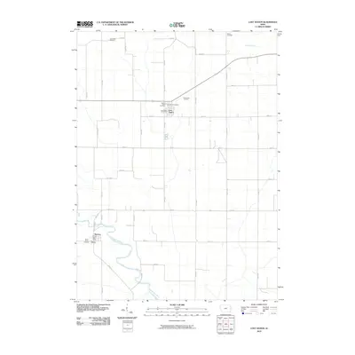
2010 Map of Lost Nation
USGS Topo · Published 2010About this map
Lost Nation stands at the center of this rural landscape, situated at the intersection of a precise grid of farm roads. The town's community infrastructure is anchored by the Lost Nation Post Office, Sacred Heart Cemetery, and the Lost Nation Cemetery. To the south, the village of Toronto lies along a sweeping bend of the Wapsipinicon River, where it is served by its own Toronto Post Office and bordered by Saint James Cemetery and Rose Hill Cemetery. The surrounding countryside is dotted with small family and community burial grounds, such as Smithtown Cemetery, Busch Cemetery, and Rustic Park Cemetery, reflecting a long history of local settlement. The terrain is defined by the winding course of Elwood Creek and the Wapsipinicon River, which contrast with the rigid township road system that organizes the agricultural parcels of Clinton County.
Find a feature on this map
34 named features on this map. Tap any name to fly to it.
Don’t see what you’re looking for? This feature index may not catch every label — zoom into the map to look around manually.
Map Details
Editions of this 2010 Lost Nation Map
This is the sole edition of this map. No revisions or reprints were ever made.
Other maps of this area

1891 · DeWitt
USGS Topo · 1:62,500

1891 · Maquoketa
USGS Topo · 1:62,500

1891 · Baldwin
USGS Topo · 1:62,500

1892 · Wheatland
USGS Topo · 1:62,500

1894 · Wheatland
USGS Topo · 1:62,500

1901 · Peosta
USGS Topo · 1:125,000

1901 · Rock Island
USGS Topo · 1:125,000

1910 · Rock Island
USGS Topo · 1:125,000
1953 · Grand Mound
USGS Topo · 1:24,000
1953 · Wheatland
USGS Topo · 1:24,000