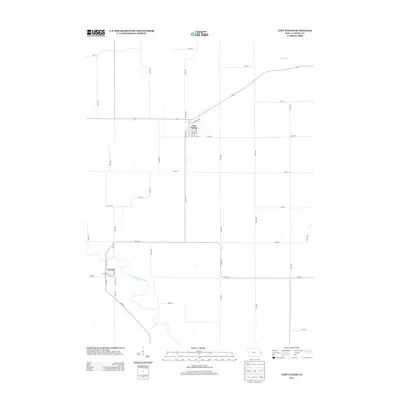
2013 Map of Lost Nation
USGS Topo · Published 2013About this map
The Wapsipinicon River meanders across the southern landscape of this Clinton County region, defining the setting for the small settlement of Toronto. Further north, the town of Lost Nation serves as a central hub, where the street grid is anchored by thoroughfares like Broadway St, Western St, and Railroad Ave. The layout of the countryside reveals a rigid section-line road network, typical of the Iowa plains, with rural routes such as 150th St and 130th Ave connecting isolated farmsteads. To the northeast, the terrain is drained by Elwood Cr, while the southern reaches near the river show more varied topography and local landmarks like Park Rd. This survey documents the persistent agricultural character of the area, punctuated by these two distinct river-and-rail settlements.
Find a feature on this map
41 named features on this map. Tap any name to fly to it.
Don’t see what you’re looking for? This feature index may not catch every label — zoom into the map to look around manually.
Map Details
Editions of this 2013 Lost Nation Map
This is the sole edition of this map. No revisions or reprints were ever made.
Other maps of this area

1891 · DeWitt
USGS Topo · 1:62,500

1891 · Maquoketa
USGS Topo · 1:62,500

1891 · Baldwin
USGS Topo · 1:62,500

1892 · Wheatland
USGS Topo · 1:62,500

1894 · Wheatland
USGS Topo · 1:62,500

1901 · Peosta
USGS Topo · 1:125,000

1901 · Rock Island
USGS Topo · 1:125,000

1910 · Rock Island
USGS Topo · 1:125,000
1953 · Grand Mound
USGS Topo · 1:24,000
1953 · Wheatland
USGS Topo · 1:24,000