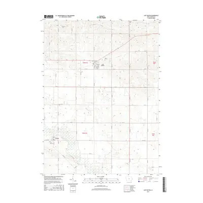
2015 Map of Lost Nation
USGS Topo · Published 2015About this map
The Wapsipinicon River winds through the southern reaches of this eastern Iowa landscape, framing a rural community centered on the towns of Lost Nation and Toronto. The map documents a structured agricultural grid defined by local routes such as Co HWY y32 and Route 136, which connects the various farmstead clusters. Notable for genealogists and local historians, this survey identifies several burial grounds that mark the heritage of the area, including Smithtown Cem, Busch Cem, and Rose Hill Cem near the banks of the river. The settlement of Lost Nation appears as a key crossroads, with its residential streets like Western St and Broadway St providing a clear view of the town's footprint. Further north, Elwood Cr cuts through the undulating fields, while Sacred Heart Cem and Rustic Park Cem stand as landmarks in the township of t83n r1e.
Find a feature on this map
47 named features on this map. Tap any name to fly to it.
Don’t see what you’re looking for? This feature index may not catch every label — zoom into the map to look around manually.
Map Details
Editions of this 2015 Lost Nation Map
This is the sole edition of this map. No revisions or reprints were ever made.
Other maps of this area

1891 · DeWitt
USGS Topo · 1:62,500

1891 · Maquoketa
USGS Topo · 1:62,500

1891 · Baldwin
USGS Topo · 1:62,500

1892 · Wheatland
USGS Topo · 1:62,500

1894 · Wheatland
USGS Topo · 1:62,500

1901 · Peosta
USGS Topo · 1:125,000

1901 · Rock Island
USGS Topo · 1:125,000

1910 · Rock Island
USGS Topo · 1:125,000
1953 · Grand Mound
USGS Topo · 1:24,000
1953 · Wheatland
USGS Topo · 1:24,000