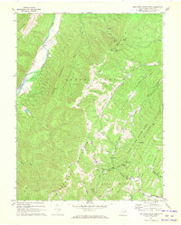
1967 Map of Lost River State Park
USGS Topo · Published 1972About this map
Lost River State Park dominates the southeastern quadrant of this Hardy County survey, established on land donated during the 1930s. The terrain is defined by a series of parallel ridges including South Fork Mountain, Hunting Ridge, and Big Ridge, which create a complex drainage system feeding the South Fork Potomac River in the northwest. Local history is preserved in the numerous small family cemeteries and the Buckhorn Ch located near the headwaters of Howards Lick Run. The era's infrastructure is visible in the Airway Beacon atop South Fork Mountain and the Big Ridge Lookout Tower, while landmarks like Helmick Rock and Cranny Crow Overlook indicate the area's established role as a destination for outdoor recreation and navigation.
Find a feature on this map
32 named features on this map. Tap any name to fly to it.
Don’t see what you’re looking for? This feature index may not catch every label — zoom into the map to look around manually.
Map Details
Editions of this 1967 Lost River State Park Map
This is the sole edition of this map. No revisions or reprints were ever made.
Other maps of this area

1891 · Romney
USGS Topo · 1:125,000

1892 · Franklin
USGS Topo · 1:125,000

1892 · Woodstock
USGS Topo · 1:125,000

1895 · Piedmont
USGS Topo · 1:125,000

1896 · Franklin
USGS Topo · 1:125,000

1920 · Petersburg
USGS Topo · 1:48,000

1920 · Moorefield
USGS Topo · 1:62,500

1921 · Orkney Springs
USGS Topo · 1:48,000

1921 · Petersburg
USGS Topo · 1:48,000

1921 · Greenland Gap
USGS Topo · 1:62,500