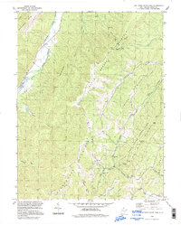
1994 Map of Lost River State Park
USGS Topo · Published 1997About this map
Shenandoah Mountain and South Branch Mountain dominate this corner of West Virginia, where the ridge-and-valley topography dictates a landscape of steep slopes and narrow drainages. The Lost River State Park core is detailed here, featuring significant hiker and administrative infrastructure including the Administration Building, multiple Shelters, and the Cranny Crow Overlook. These peaks offer a clear view of the region's 1960s-era utility and safety network, marked by the presence of an Airway Beacon and the Big Ridge Lookout Tower.
Find a feature on this map
34 named features on this map. Tap any name to fly to it.
Don’t see what you’re looking for? This feature index may not catch every label — zoom into the map to look around manually.
Map Details
Editions of this 1994 Lost River State Park Map
This is the sole edition of this map. No revisions or reprints were ever made.
Other maps of this area

1891 · Romney
USGS Topo · 1:125,000

1892 · Franklin
USGS Topo · 1:125,000

1892 · Woodstock
USGS Topo · 1:125,000

1895 · Piedmont
USGS Topo · 1:125,000

1896 · Franklin
USGS Topo · 1:125,000

1920 · Petersburg
USGS Topo · 1:48,000

1920 · Moorefield
USGS Topo · 1:62,500

1921 · Orkney Springs
USGS Topo · 1:48,000

1921 · Petersburg
USGS Topo · 1:48,000

1921 · Greenland Gap
USGS Topo · 1:62,500