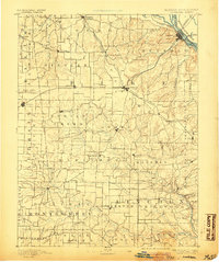
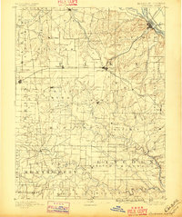
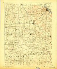
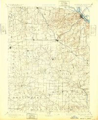
1890 Map of Louisiana
USGS Topo · Published 1905About this map
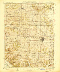
Louisiana sits at the northeastern corner of this 1890s survey, marking a vital junction between the Mississippi River and the St. Louis Keokuk and Northwestern Railroad. The landscape reflects a late 19th-century economy driven by river transport and expanding rail lines, including the Chicago and Alton Railroad which connects Bowling Green and Curryville. Further west, the drainage of the Salt River and its tributaries like Spencer Creek define the agricultural layout of township units such as Hartford and Indian Creek. Genealogists will find a wealth of localized detail in smaller settlements like Millwood Mills, Mc Cunes Station, and New Hartford, which served as rural hubs before the consolidation of local trade centers. The map also captures the Illinois Missouri Boundary Line along the river's main channel, showcasing the intricate shoreline as it appeared before modern navigational modifications.
Find a feature on this map
105 named features on this map. Tap any name to fly to it.
Don’t see what you’re looking for? This feature index may not catch every label — zoom into the map to look around manually.
Map Details
Editions of this 1890 Louisiana Map
5 editions found
Other maps of this area

1890 · Louisiana
USGS Topo · 1:125,000

1890 · Mexico
USGS Topo · 1:125,000

1890 · Hermann
USGS Topo · 1:125,000

1890 · Fulton
USGS Topo · 1:125,000

1903 · O'Fallon
USGS Topo · 1:125,000

1903 · Palmyra
USGS Topo · 1:125,000
1926 · Pittsfield
USGS Topo · 1:62,500

1930 · Nebo
USGS Topo · 1:62,500

1931 · Barry
USGS Topo · 1:62,500

1932 · Hannibal
USGS Topo · 1:62,500