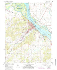
1978 Map of Louisiana
USGS Topo · Published 1985About this map
The Mississippi River dominates the eastern edge of this Missouri-Illinois borderland, where Louisiana serves as a primary hub for river and rail transit. During the late 1970s and early 1980s, the area maintained its industrial and agricultural footing, with numerous quarries and a heavy rail presence from the Burlington Northern and Gulf Illinois Central lines. The landscape north of town is defined by a complex network of waterways, including the Salt River, Horseshoe Lake, and Angle Island, much of which is preserved within the Ted Shanks State Wildlife Management Area.
Find a feature on this map
62 named features on this map. Tap any name to fly to it.
Don’t see what you’re looking for? This feature index may not catch every label — zoom into the map to look around manually.
Map Details
Editions of this 1978 Louisiana Map
2 editions found
Other maps of this area

1890 · Louisiana
USGS Topo · 1:125,000

1926 · Pittsfield
USGS Topo · 1:62,500

1930 · Nebo
USGS Topo · 1:62,500

1931 · Barry
USGS Topo · 1:62,500

1934 · Nebo
USGS Topo · 1:48,000

1936 · Barry
USGS Topo · 1:48,000

1937 · Bowling Green
USGS Topo · 1:62,500

1940 · Bowling Green
USGS Topo · 1:62,500

1942 · Nebo
USGS Topo · 1:62,500

1944 · Barry
USGS Topo · 1:62,500