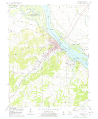
1978 Map of Louisiana
USGS Topo · Published 1978About this map
Louisiana sits at the prominent confluence of the Mississippi River and the Salt River, serving as a vital transportation hub in the late 1970s. The town's industrial and river-faring character is evidenced by the presence of a boat ramp, Two Rivers Marina, and multiple quarries scattered along the river bluffs. To the north, the Ted Shanks State Wildlife Management Area and the Mark Twain National Wildlife Refuge preserve the intricate river bottomlands of Angle Island and Blackburn Island.
Find a feature on this map
64 named features on this map. Tap any name to fly to it.
Don’t see what you’re looking for? This feature index may not catch every label — zoom into the map to look around manually.
Map Details
Editions of this 1978 Louisiana Map
2 editions found
Other maps of this area

1890 · Louisiana
USGS Topo · 1:125,000

1926 · Pittsfield
USGS Topo · 1:62,500

1930 · Nebo
USGS Topo · 1:62,500

1931 · Barry
USGS Topo · 1:62,500

1934 · Nebo
USGS Topo · 1:48,000

1936 · Barry
USGS Topo · 1:48,000

1937 · Bowling Green
USGS Topo · 1:62,500

1940 · Bowling Green
USGS Topo · 1:62,500

1942 · Nebo
USGS Topo · 1:62,500

1944 · Barry
USGS Topo · 1:62,500