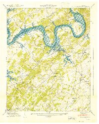
1941 Map of Louisville
USGS Topo · Published 1941About this map
The Tennessee River dominates this 1941 landscape, winding through a complex series of bends including Jones Bend, Keller Bend, and Toole Bend. This survey captures the region just as the Fort Loudoun Reservoir was being planned, with the proposed pool elevation marked against the existing riverbanks and islands like Henson Island and Postoak Island. This transition from river to reservoir is documented alongside established communities such as Louisville and Miser Station.
Find a feature on this map
80 named features on this map. Tap any name to fly to it.
Don’t see what you’re looking for? This feature index may not catch every label — zoom into the map to look around manually.
Map Details
Editions of this 1941 Louisville Map
This is the sole edition of this map. No revisions or reprints were ever made.
Other maps of this area

1886 · Knoxville
USGS Topo · 1:125,000

1892 · Knoxville
USGS Topo · 1:125,000

1894 · Knoxville
USGS Topo · 1:125,000

1895 · Loudon
USGS Topo · 1:125,000

1895 · Knoxville
USGS Topo · 1:125,000

1901 · Knoxville
USGS Topo · 1:125,000

1935 · Binfield
USGS Topo · 1:24,000

1935 · Knoxville
USGS Topo · 1:48,000

1935 · Meadow
USGS Topo · 1:24,000

1935 · Maryville
USGS Topo · 1:24,000