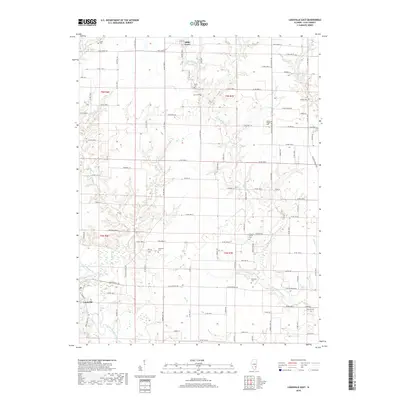
2018 Map of Louisville East
USGS Topo · Published 2018About this map
The Little Wabash River defines the southwestern corner of this Clay County landscape, where the settlement of Louisville sits at the intersection of river and road. To the north, the community of Bible Grove anchors a rural grid characterized by scriptural and nature-themed road names such as Testament Ln, Proverbs Ln, and Spoonbill Rd. This 2018 survey reveals a territory dense with family and community burial grounds, including Kinnamon Cem, Hoosier Prairie Cem, and Shouse Chapel Cem, which offer significant data points for genealogical research. The drainage network is complex, featuring Little Muddy Cr, Panther Cr, and Flat Br cutting through the agricultural sections. The map's layout of county roads and named lanes reflects a modern interpretation of the long-standing Illinois township and range system, preserving the spatial relationship between isolated farmsteads and established crossroads.
Find a feature on this map
68 named features on this map. Tap any name to fly to it.
Don’t see what you’re looking for? This feature index may not catch every label — zoom into the map to look around manually.
Map Details
Editions of this 2018 Louisville East Map
This is the sole edition of this map. No revisions or reprints were ever made.
Other maps of this area

1948 · Flora
USGS Topo · 1:62,500

1949 · Flora
USGS Topo · 1:62,500

1952 · Xenia
USGS Topo · 1:62,500

1953 · Sailor Springs
USGS Topo · 1:62,500

1956 · Edgewood
USGS Topo · 1:62,500

1958 · Belleville
USGS Topo · 1:250,000

1962 · Belleville
USGS Topo · 1:250,000
1968 · Xenia NE
USGS Topo · 1:24,000

1970 · Clay City
USGS Topo · 1:24,000
1970 · Flora
USGS Topo · 1:24,000