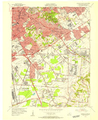
1955 Map of Louisville East
USGS Topo · Published 1956About this map
Louisville undergoes a period of significant postwar expansion as recorded in this mid-century survey, which details the sprawling suburban developments and vital infrastructure south and east of the city core. The landscape is defined by the emergence of the Louisville Expressway and Watterson Expressway, cutting through established neighborhoods like Highlands and Audubon Park. Major institutional sites such as Bellarmine College, St Josephs Infirmary, and the U S Army Medical Depot are documented alongside extensive burial grounds including Calvary Cemetery and Evergreen Cemetery. Aviation plays a central role in the regional layout, anchored by both Standiford Field and Bowman Field. These commercial and military hubs are linked by the Louisville and Nashville and Southern railroads, while smaller communities like Okolona and Buechel begin to coalesce into the larger metropolitan area.
Find a feature on this map
105 named features on this map. Tap any name to fly to it.
Don’t see what you’re looking for? This feature index may not catch every label — zoom into the map to look around manually.
Map Details
Editions of this 1955 Louisville East Map
This is the sole edition of this map. No revisions or reprints were ever made.
Other maps of this area

1905 · Prospect
USGS Topo · 1:62,500

1907 · Louisville
USGS Topo · 1:62,500

1909 · Kosmosdale
USGS Topo · 1:48,000

1912 · Prospect
USGS Topo · 1:62,500

1912 · Kosmosdale
USGS Topo · 1:62,500

1937 · Jeffersonville
USGS Topo · 1:24,000

1939 · New Albany
USGS Topo · 1:24,000

1946 · Jeffersonville
USGS Topo · 1:24,000

1946 · New Albany
USGS Topo · 1:24,000
1950 · New Albany
USGS Topo · 1:24,000