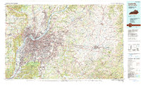
1956 Map of Louisville
USGS Topo · Published 1976About this map
The Ohio River corridor serves as the central artery for this mid-century portrait of northern Kentucky and southern Indiana. At this time, the urban centers of Louisville and Lexington are connected by a dense lattice of major railroads, including the Louisville & Nashville RR and the Southern Ry. The landscape is defined by significant federal and state holdings, from the sprawling Fort Knox Military Reservation in the southwest to the Jefferson Proving Ground in Indiana. Topographic transitions are marked by the Knobs and the prominent Muldraugh Hill, while the river systems of the Kentucky River, Licking River, and Muscatatuck River carve through the limestone plateau. This 1956 compilation, updated in 1969, captures the region's post-war infrastructure just as the interstate highway system, including I-64 and I-75, began to reshape the Bluegrass State.
Find a feature on this map
91 named features on this map. Tap any name to fly to it.
Don’t see what you’re looking for? This feature index may not catch every label — zoom into the map to look around manually.
Map Details
Editions of this 1956 Louisville Map
2 editions found

Historical Maps of Louisville Through Time
5 maps found