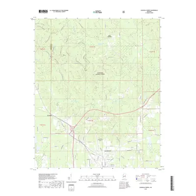
2018 Map of Louisville North
USGS Topo · Published 2018About this map
The northern reaches of Louisville and the expansive Tombigbee National Forest define this 2018 survey of Winston County. The landscape is characterized by a dense network of watercourses, including the Noxubee River and the Little Noxubee River, which wind through the forested terrain alongside smaller tributaries like Town Cr and Murphy Cr. This era shows a mix of municipal development near the Louisville Winston County Airport and a vast system of recreational and access trails within the national forest, such as Charlotte's Web Trail and the Pigeon Roost Road Trail. For genealogists and local historians, the map identifies specific burial sites like Noxubee Hill Cem and Little Rock Cem, providing precise locations for these community landmarks. Smaller settlements like Gum Springs and McMillan are situated along the primary road corridors, reflecting the area's rural residential patterns.
Find a feature on this map
82 named features on this map. Tap any name to fly to it.
Don’t see what you’re looking for? This feature index may not catch every label — zoom into the map to look around manually.
Map Details
Editions of this 2018 Louisville North Map
This is the sole edition of this map. No revisions or reprints were ever made.
Other maps of this area

1953 · West Point
USGS Topo · 1:250,000

1958 · West Point
USGS Topo · 1:250,000

1963 · West Point
USGS Topo · 1:250,000

1965 · Bradley
USGS Topo · 1:24,000

1972 · Louisville North
USGS Topo · 1:24,000

1972 · Highpoint
USGS Topo · 1:24,000
1972 · Louisville South
USGS Topo · 1:24,000
1972 · Louisville SW
USGS Topo · 1:24,000

1972 · Sturgis
USGS Topo · 1:24,000
1972 · Ackerman
USGS Topo · 1:24,000