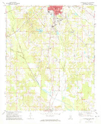
1972 Map of Louisville South
USGS Topo · Published 1973About this map
Louisville serves as the primary hub of this 1970s survey, with its concentrated urban grid featuring the Courthouse, City Hall, and a local Jr High Sch. The town's industrial and infrastructure footprint is evident through the Gulf Mobile and Ohio railroad corridor and facilities like the Sewage Disposal Pond and Radio Tower (WLSM). Just south of the city, the landscape transitions into a mix of recreational and rural spaces, including a Golf Course and the waters of Lake Tiak-O'Khata.
Find a feature on this map
35 named features on this map. Tap any name to fly to it.
Don’t see what you’re looking for? This feature index may not catch every label — zoom into the map to look around manually.
Map Details
Editions of this 1972 Louisville South Map
2 editions found
Other maps of this area

1953 · Meridian
USGS Topo · 1:250,000

1953 · West Point
USGS Topo · 1:250,000

1957 · Meridian
USGS Topo · 1:250,000

1958 · West Point
USGS Topo · 1:250,000

1962 · Vernon
USGS Topo · 1:24,000

1963 · West Point
USGS Topo · 1:250,000

1965 · Meridian
USGS Topo · 1:250,000

1972 · Louisville North
USGS Topo · 1:24,000

1972 · Highpoint
USGS Topo · 1:24,000

1972 · Plattsburg
USGS Topo · 1:24,000