
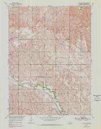
1953 Map of Loup City SE
USGS Topo · Published 1955About this map
Oak Creek meanders through the central Nebraska plains, defining a landscape of deeply dissected ridges and drainage basins as they appeared in the early 1950s. The village of Ashton serves as the primary hub in the south, situated along the Chicago Burlington and Quincy railroad line that follows the natural grade of the creek valley. This survey reveals a high density of rural infrastructure typical of the era, with schoolhouses such as School No 77, School No 56, and School No 22 distributed across the terrain to serve a dispersed farming population. The mapping of Shaupps Sch and various section-line roads illustrates the systematic grid of the American West superimposed upon the winding path of Turkey Creek.
Find a feature on this map
12 named features on this map. Tap any name to fly to it.
Don’t see what you’re looking for? This feature index may not catch every label — zoom into the map to look around manually.
Map Details
Editions of this 1953 Loup City SE Map
2 editions found
Other maps of this area

1899 · Loup
USGS Topo · 1:125,000

1953 · Loup City NW
USGS Topo · 1:24,000

1953 · Cotesfield
USGS Topo · 1:24,000

1953 · North Loup
USGS Topo · 1:24,000

1953 · Scotia
USGS Topo · 1:24,000

1953 · Ravenna NW
USGS Topo · 1:24,000

1953 · Loup City
USGS Topo · 1:24,000

1953 · Farwell
USGS Topo · 1:24,000

1953 · Ashton
USGS Topo · 1:24,000

1955 · Broken Bow
USGS Topo · 1:250,000