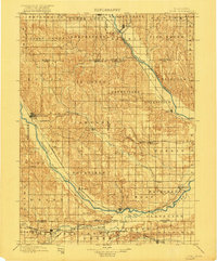
1899 Map of Loup
USGS Topo · Published 1921About this map
The confluence of the Middle Loup River and North Loup River dictates the settlement patterns of this central Nebraska landscape in the late 19th century. Established towns such as Loup City, Dannebrog, and Ashton are strategically positioned along the river valleys, where the Union Pacific RR and the Burlington and Missouri River RR provided essential connections to the wider world. The map reveals a dense network of smaller communities like Nysted, Verdurette, and Dannevirke, many of which were centers of immigrant settlement and agricultural trade during this era of rapid prairie development.
Find a feature on this map
61 named features on this map. Tap any name to fly to it.
Don’t see what you’re looking for? This feature index may not catch every label — zoom into the map to look around manually.
Map Details
Editions of this 1899 Loup Map
2 editions found
Other maps of this area

1892 · Grand Island
USGS Topo · 1:62,500

1895 · Grand Island
USGS Topo · 1:62,500

1895 · Wood River
USGS Topo · 1:62,500

1896 · Kearney
USGS Topo · 1:125,000

1896 · Wood River
USGS Topo · 1:125,000

1898 · Grand Island
USGS Topo · 1:125,000

1899 · Loup
USGS Topo · 1:125,000

1899 · St. Paul
USGS Topo · 1:125,000

1951 · Arcadia SE
USGS Topo · 1:24,000

1951 · Litchfield NE
USGS Topo · 1:24,000