
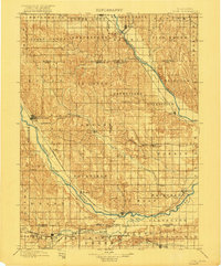
1899 Map of Loup
USGS Topo · Published 1899About this map
The branching waters of the North Fork Loup River, Middle Fork Loup River, and South Fork Loup River converge in this late nineteenth-century Nebraska landscape. The region is defined by its early rail network, including the Union Pacific RR and the Burlington and Missouri River RR, which facilitated the growth of several pioneer settlements. The cultural heritage of the area is visible in places like the Danish-founded Dannevirke and Dannebrog, reflecting the strong Scandinavian influence on the plains during this era. Other central hubs such as Ashton, Scotia, and Rockville are situated among a landscape of creek-fed townships like Warsaw, Ashton, and Oak Creek. This survey captures a specific moment when these valley towns and upland townships were becoming established centers of commerce and rail transport along the Loup river system.
Find a feature on this map
69 named features on this map. Tap any name to fly to it.
Don’t see what you’re looking for? This feature index may not catch every label — zoom into the map to look around manually.
Map Details
Editions of this 1899 Loup Map
2 editions found
Other maps of this area

1892 · Grand Island
USGS Topo · 1:62,500

1895 · Grand Island
USGS Topo · 1:62,500

1895 · Wood River
USGS Topo · 1:62,500

1896 · Kearney
USGS Topo · 1:125,000

1896 · Wood River
USGS Topo · 1:125,000

1898 · Grand Island
USGS Topo · 1:125,000

1899 · St. Paul
USGS Topo · 1:125,000

1951 · Arcadia SE
USGS Topo · 1:24,000

1951 · Litchfield NE
USGS Topo · 1:24,000

1951 · Hazard
USGS Topo · 1:24,000