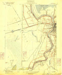
1916 Map of Lovdal
USGS Topo · Published 1916About this map
The Sacramento River meanders through a landscape defined by complex water management and early twentieth-century transit infrastructure. This area, dominated by the American Basin and the Yolo and Sacramento County boundary, reveals a period when reclamation efforts were actively reshaping the floodplains. Features like the Lovdal Levee and several pumping plants highlight the struggle to reclaim land for agriculture and settlement. The river's path is marked by significant landmarks such as Washington Broderick P O and Sutterville, illustrating the early growth of the region.
Find a feature on this map
43 named features on this map. Tap any name to fly to it.
Don’t see what you’re looking for? This feature index may not catch every label — zoom into the map to look around manually.
Map Details
Editions of this 1916 Lovdal Map
This is the sole edition of this map. No revisions or reprints were ever made.
Other maps of this area

1891 · Sacramento
USGS Topo · 1:125,000

1892 · Sacramento
USGS Topo · 1:125,000

1893 · Sacramento
USGS Topo · 1:125,000

1894 · Lodi
USGS Topo · 1:125,000

1902 · Fairoaks
USGS Topo · 1:62,500

1907 · Davisville
USGS Topo · 1:62,500

1908 · Courtland
USGS Topo · 1:62,500

1909 · Florin
USGS Topo · 1:31,680

1911 · Brighton
USGS Topo · 1:31,680

1911 · Arcade
USGS Topo · 1:31,680
Featured Places
- Sacramento, CA
- West Sacramento, CA
- Mikon, West Sacramento
- Riverview, West Sacramento
- Lovdal, West Sacramento