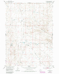
1952 Map of Love Ranch
USGS Topo · Published 1985About this map
Love Ranch and the surrounding rangeland of Fremont County are documented here as they appeared during the early 1950s, with later updates from the 1980s. The landscape is defined by its ranching infrastructure, featuring isolated sites like the Roberts Sheep Camp, a Sheep Shed, and several vital water sources such as Fraser Reservoir and Sulphur Spring. The northern portion of the map is marked by the distinct Buffalo Wallows, while the southern reaches are dominated by the eroded formations of Castle Gardens.
Find a feature on this map
22 named features on this map. Tap any name to fly to it.
Don’t see what you’re looking for? This feature index may not catch every label — zoom into the map to look around manually.
Map Details
Editions of this 1952 Love Ranch Map
2 editions found
Other maps of this area

1952 · Seventy-one Reservoir
USGS Topo · 1:24,000

1952 · Squaw Butte
USGS Topo · 1:24,000

1952 · Rongis Reservoir SE
USGS Topo · 1:24,000

1952 · Love Ranch
USGS Topo · 1:24,000

1952 · Gas Hills
USGS Topo · 1:24,000

1952 · Puddle Springs
USGS Topo · 1:24,000

1952 · Butte Well
USGS Topo · 1:24,000

1952 · Moneta SE
USGS Topo · 1:24,000

1952 · Miles Ranch
USGS Topo · 1:24,000

1955 · Arminto
USGS Topo · 1:250,000