
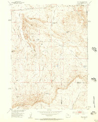
1952 Map of Gas Hills
USGS Topo · Published 1953About this map
Beaver Rim dominates the southern landscape of this 1952 survey, marking the dramatic boundary where the High Plains drop away at the Fremont and Natrona County line. This arid basin, mapped as part of the Missouri River Basin development program, captures the area just as uranium exploration began to transform the Gas Hills. While the landscape is defined by drainage systems like Fraser Draw and Reid Draw, human activity is limited to a few water developments such as Medicine Springs Reservoir and Canyon Creek Reservoir. Evidence of early industrial attempts appears in the Dutton Basin, where an Oil Well (Aband) and various unimproved trails suggest the search for natural resources in this isolated terrain. The map serves as a primary record of the topography before significant mining infrastructure altered the local surface.
Find a feature on this map
18 named features on this map. Tap any name to fly to it.
Don’t see what you’re looking for? This feature index may not catch every label — zoom into the map to look around manually.
Map Details
Editions of this 1952 Gas Hills Map
2 editions found
Other maps of this area

1952 · Ervay Basin SW
USGS Topo · 1:24,000

1952 · Love Ranch
USGS Topo · 1:24,000

1952 · Puddle Springs
USGS Topo · 1:24,000

1952 · Miles Ranch
USGS Topo · 1:24,000

1952 · Coyote Springs
USGS Topo · 1:24,000

1952 · Ervay Basin
USGS Topo · 1:24,000

1952 · Mc Intosh Meadows
USGS Topo · 1:24,000

1955 · Casper
USGS Topo · 1:250,000

1957 · Miles Ranch
USGS Topo · 1:24,000
1957 · Puddle Springs
USGS Topo · 1:24,000