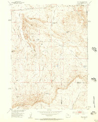
1952 Map of Gas Hills
USGS Topo · Published 1956About this map
The Gas Hills of central Wyoming define this 1952 topographic study, showing a landscape of high desert drainage and early industrial exploration. The map captures the rugged interior of the Dutton Basin just as the region began to draw attention for its mineral potential, though at this date the human footprint is limited to scattered infrastructure like the Pipe Line and several Oil Well (Aband) sites. The stark topography is dominated by the massive Beaver Rim escarpment in the south, which creates a dramatic natural boundary between the basin floor and the higher plateaus. Hydrology is central to the area's layout, with numerous drainage features such as Fraser Draw and West Canyon Creek feeding into isolated stock water locations like Medicine Springs Reservoir and Iron Springs Reservoir. The boundary between Fremont Co and Natrona Co cuts across the northeastern and southern sections, marking the political lines in this largely uninhabited territory.
Find a feature on this map
20 named features on this map. Tap any name to fly to it.
Don’t see what you’re looking for? This feature index may not catch every label — zoom into the map to look around manually.
Map Details
Editions of this 1952 Gas Hills Map
2 editions found
Other maps of this area

1952 · Ervay Basin SW
USGS Topo · 1:24,000

1952 · Love Ranch
USGS Topo · 1:24,000

1952 · Gas Hills
USGS Topo · 1:24,000

1952 · Puddle Springs
USGS Topo · 1:24,000

1952 · Miles Ranch
USGS Topo · 1:24,000

1952 · Coyote Springs
USGS Topo · 1:24,000

1952 · Ervay Basin
USGS Topo · 1:24,000

1952 · Mc Intosh Meadows
USGS Topo · 1:24,000

1955 · Casper
USGS Topo · 1:250,000

1957 · Miles Ranch
USGS Topo · 1:24,000