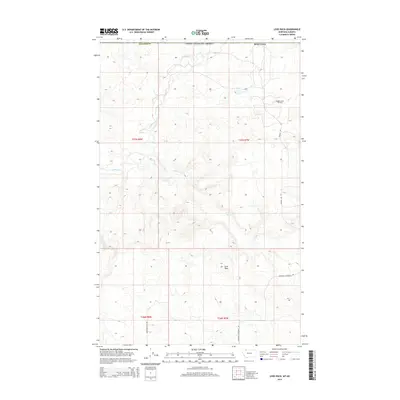
2014 Map of Love Rock
USGS Topo · Published 2014About this map
Milk River meanders across this northern Montana landscape, where the high plains meet the international border in Glacier County. The terrain is defined by its isolation and the natural landmark of Love Rock, a prominent elevation point in the southern portion of the quadrangle. Resource extraction is a primary feature of the local economy, evidenced by the Reagan Camp Oil Field situated in the northeast.
Find a feature on this map
14 named features on this map. Tap any name to fly to it.
Don’t see what you’re looking for? This feature index may not catch every label — zoom into the map to look around manually.
Map Details
Editions of this 2014 Love Rock Map
This is the sole edition of this map. No revisions or reprints were ever made.
Other maps of this area

1909 · Cut Bank
USGS Topo · 1:125,000

1911 · Blackfoot
USGS Topo · 1:125,000

1912 · Cut Bank
USGS Topo · 1:125,000

1960 · Cut Bank
USGS Topo · 1:250,000

1963 · Cut Bank
USGS Topo · 1:250,000

1964 · Cut Bank
USGS Topo · 1:250,000

1968 · Buffalo Lake
USGS Topo · 1:24,000
1968 · Dead Indian Spring
USGS Topo · 1:24,000
1968 · Love Rock
USGS Topo · 1:24,000

1968 · Rocky Buttes
USGS Topo · 1:24,000