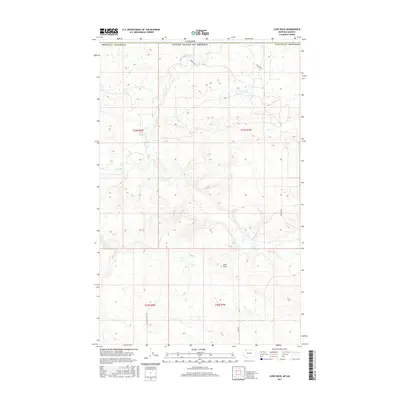
2017 Map of Love Rock
USGS Topo · Published 2017About this map
The Canada United States of America international boundary defines the northern limit of this high-plains landscape in Glacier County, Montana. The serpentine course of the Milk River meanders across the northwestern corner, carving a distinct valley through the open terrain. Prominent landmarks such as Love Rock and the water source at Antelope Spring provide essential orientation points in a region dominated by vast sections of public land. The road network is sparse, primarily consisting of the north-south Landslide Butte Rd and the winding Reagan Rd, which facilitate movement between the various townships and ranges that grid the area. This 2017 survey illustrates the enduring rural character of the northern frontier, where the geography is defined more by natural watercourses and terrain features than by urban development.
Find a feature on this map
11 named features on this map. Tap any name to fly to it.
Don’t see what you’re looking for? This feature index may not catch every label — zoom into the map to look around manually.
Map Details
Editions of this 2017 Love Rock Map
This is the sole edition of this map. No revisions or reprints were ever made.
Other maps of this area

1909 · Cut Bank
USGS Topo · 1:125,000

1911 · Blackfoot
USGS Topo · 1:125,000

1912 · Cut Bank
USGS Topo · 1:125,000

1960 · Cut Bank
USGS Topo · 1:250,000

1963 · Cut Bank
USGS Topo · 1:250,000

1964 · Cut Bank
USGS Topo · 1:250,000

1968 · Buffalo Lake
USGS Topo · 1:24,000
1968 · Dead Indian Spring
USGS Topo · 1:24,000
1968 · Love Rock
USGS Topo · 1:24,000

1968 · Rocky Buttes
USGS Topo · 1:24,000