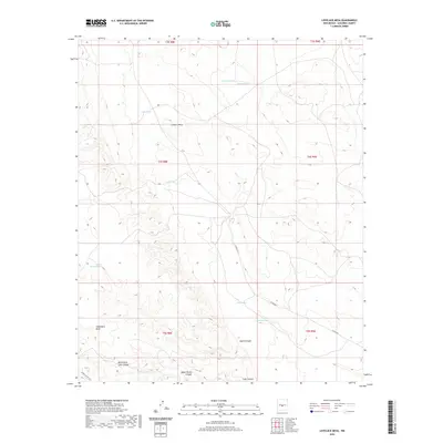
2020 Map of Lovelace Mesa
USGS Topo · Published 2020About this map
Lovelace Mesa and the expansive Chupadera Mesa dominate this Socorro County landscape, reflecting the characteristic high-desert topography of central New Mexico. The drainage patterns here are defined by long, ephemeral watercourses like School Section Draw and Harvey Draw, while human activity is evidenced by scattered water catchments essential for ranching, such as Berry Tank, Lake Tank, and the Line Tanks. In the southern portion of the sheet, the terrain drops into deep, branching drainages including Aguila Canyon, North Fork Lobo Canyon, and Lobo Canyon. The sparse infrastructure is limited to a few thoroughfares like Co RD a012 and the WSMR S Route 3511, suggesting a largely undeveloped area primarily utilized for grazing or military proximity.
Find a feature on this map
20 named features on this map. Tap any name to fly to it.
Don’t see what you’re looking for? This feature index may not catch every label — zoom into the map to look around manually.
Map Details
Editions of this 2020 Lovelace Mesa Map
This is the sole edition of this map. No revisions or reprints were ever made.
Other maps of this area

1918 · Oscura Peak
USGS Topo · 1:125,000

1948 · Broken Back Crater
USGS Topo · 1:62,500

1950 · Little Black Peak
USGS Topo · 1:62,500

1954 · Tularosa
USGS Topo · 1:250,000

1954 · Fort Sumner
USGS Topo · 1:250,000

1954 · Socorro
USGS Topo · 1:250,000

1955 · Roswell
USGS Topo · 1:250,000

1958 · Socorro
USGS Topo · 1:250,000

1958 · Fort Sumner
USGS Topo · 1:250,000

1958 · Roswell
USGS Topo · 1:250,000