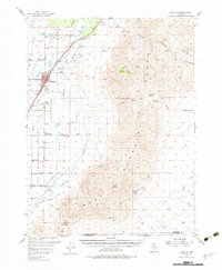
1956 Map of Lovelock
USGS Topo · Published 1982About this map
Lovelock and its surrounding agricultural valley are defined by the intricate irrigation network of the Humboldt River, featuring prominent water control structures like Pitt Dam and Rodgers Dam. The 1950s landscape reflects a transition between established ranching operations, such as the Circle L Ranch and Tule Ranch, and the industrial pulse of the Southern Pacific railroad corridor. While the town center shows organized municipal infrastructure including a sewage disposal site and Lovelock Airport, the eastern heights of Humboldt West remain the domain of resource extraction.
Find a feature on this map
44 named features on this map. Tap any name to fly to it.
Don’t see what you’re looking for? This feature index may not catch every label — zoom into the map to look around manually.
Map Details
Editions of this 1956 Lovelock Map
3 editions found

Other maps of this area

1908 · Carson Sink
USGS Topo · 1:250,000

1910 · Carson Sink
USGS Topo · 1:250,000

1931 · Lovelock
USGS Topo · 1:250,000

1935 · Lovelock
USGS Topo · 1:250,000

1951 · Carson Sink
USGS Topo · 1:62,500

1954 · Unionville
USGS Topo · 1:62,500

1954 · Buffalo Mtn
USGS Topo · 1:62,500

1955 · Lovelock
USGS Topo · 1:250,000

1956 · Oreana
USGS Topo · 1:62,500

1956 · Toulon
USGS Topo · 1:62,500