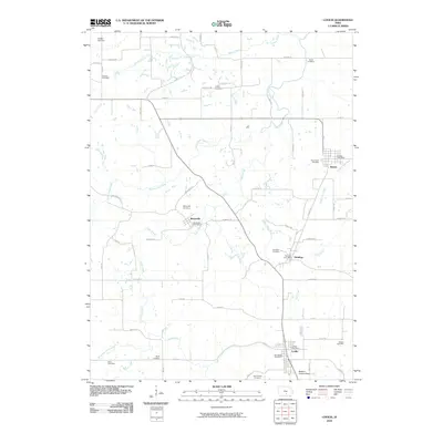
2010 Map of Lovilia
USGS Topo · Published 2010About this map
The town of Lovilia and the surrounding townships in Marion and Monroe Counties are defined by a network of rural crossroads and persistent small-town centers. This 2010 survey documents the enduring settlement patterns of Bussey, Marysville, and Hamilton, each retaining its own post office and local identity. The landscape is deeply carved by water, with Cedar Creek and its many tributaries, such as North Cedar Creek and Whippoorwill Branch, dictating the placement of secondary roads like Van Buren Dr and Wyoming St. Genealogy researchers will find a significant number of family and community burial grounds across the quadrangle, including the Carlisle Cemetery, Bridges Cemetery, and Osborn Cemetery. The presence of the Weldon Landing Strip near Lovilia marks a modern utility in this predominantly agricultural region, while the various creek-named labels like North Coal Creek hint at the area's geological and industrial heritage.
Find a feature on this map
53 named features on this map. Tap any name to fly to it.
Don’t see what you’re looking for? This feature index may not catch every label — zoom into the map to look around manually.
Map Details
Editions of this 2010 Lovilia Map
This is the sole edition of this map. No revisions or reprints were ever made.
Other maps of this area

1909 · Knoxville
USGS Topo · 1:62,500

1910 · Pella
USGS Topo · 1:62,500

1912 · Knoxville
USGS Topo · 1:62,500

1912 · Pella
USGS Topo · 1:62,500

1924 · Melcher
USGS Topo · 1:62,500

1929 · Albia
USGS Topo · 1:62,500

1954 · Des Moines
USGS Topo · 1:250,000

1956 · Des Moines
USGS Topo · 1:250,000

1957 · Des Moines
USGS Topo · 1:250,000
1965 · Knoxville
USGS Topo · 1:24,000