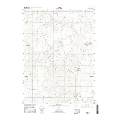
2015 Map of Lovilia
USGS Topo · Published 2015About this map
Lovilia serves as a focal point in this 2015 survey of the border region between Marion and Monroe counties. The landscape is defined by the winding paths of Cedar Creek and Coal Creek, which create a complex system of ridges and valleys that dictate the placement of small towns and rural roads. Significant for genealogical research, the area is dotted with numerous small burial grounds including Saint Peters Cemetery and Woodlawn Cemetery. To the north, the settlements of Marysville and Hamilton are linked by a network of local routes like Vermont Drive and Trinkle Drive. The presence of many family-named landmarks, such as Doud Cemetery and Boyer Cemetery, provides a clear view into the long-standing land ownership and community structure of this agricultural interior.
Find a feature on this map
59 named features on this map. Tap any name to fly to it.
Don’t see what you’re looking for? This feature index may not catch every label — zoom into the map to look around manually.
Map Details
Editions of this 2015 Lovilia Map
This is the sole edition of this map. No revisions or reprints were ever made.
Other maps of this area

1909 · Knoxville
USGS Topo · 1:62,500

1910 · Pella
USGS Topo · 1:62,500

1912 · Knoxville
USGS Topo · 1:62,500

1912 · Pella
USGS Topo · 1:62,500

1924 · Melcher
USGS Topo · 1:62,500

1929 · Albia
USGS Topo · 1:62,500

1954 · Des Moines
USGS Topo · 1:250,000

1956 · Des Moines
USGS Topo · 1:250,000

1957 · Des Moines
USGS Topo · 1:250,000
1965 · Knoxville
USGS Topo · 1:24,000