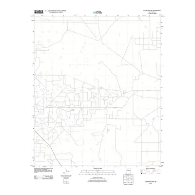
2010 Map of Lovington SW
USGS Topo · Published 2010About this map
The Vacuum Oil Field dominates this section of the Permian Basin, where the industrial footprint of energy extraction intersects with traditional ranching operations. The landscape is characterized by a dense network of access roads and pads serving the petroleum industry, primarily centered along County Rd-50. Amidst this energy-producing infrastructure, family-named landmarks such as the R D Lee Ranch and Giles Lee Ranch reflect the persistent pastoral roots of Lea County. The grid-like patterns of rural routes, including County Rd-53, provide a structural framework for this remote high-plains terrain, illustrating how 21st-century resource development has integrated with the expansive ranching heritage of southeastern New Mexico.
Find a feature on this map
5 named features on this map. Tap any name to fly to it.
Don’t see what you’re looking for? This feature index may not catch every label — zoom into the map to look around manually.
Map Details
Editions of this 2010 Lovington SW Map
This is the sole edition of this map. No revisions or reprints were ever made.
Other maps of this area

1954 · Hobbs
USGS Topo · 1:250,000

1958 · Hobbs
USGS Topo · 1:250,000

1962 · Lovington
USGS Topo · 1:24,000

1962 · Lovington
USGS Topo · 1:62,500

1962 · Buckeye
USGS Topo · 1:62,500

1963 · Monument
USGS Topo · 1:62,500

1963 · Laguna Gatuna
USGS Topo · 1:62,500

1984 · Ironhouse Well
USGS Topo · 1:24,000
1985 · Monument North
USGS Topo · 1:24,000
1985 · Lovington NW
USGS Topo · 1:24,000