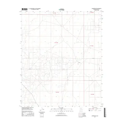
2017 Map of Lovington SW
USGS Topo · Published 2017About this map
The High Plains of Lea County reveal an intricate network of rural corridors and section lines in this late 2010s survey. The landscape is defined by the intersection of Buckeye Rd and Swamp Rd, which serve as primary conduits through this part of the Llano Estacado. The survey meticulously documents the township and range boundaries of t17s r35e and surrounding sections, providing a clear picture of the land divisions used for ranching and resource extraction. Evidence of the region’s agricultural and ranching heritage is visible along Lee Ranch Rd, while the presence of Numerous depressions and catchments across the terrain highlights the unique hydrology of this semi-arid plateau. Local thoroughfares like Co Rd 78 and Co Rd 53 provide essential connectivity between the scattered homesteads and industrial sites that characterize this corner of New Mexico.
Find a feature on this map
11 named features on this map. Tap any name to fly to it.
Don’t see what you’re looking for? This feature index may not catch every label — zoom into the map to look around manually.
Map Details
Editions of this 2017 Lovington SW Map
This is the sole edition of this map. No revisions or reprints were ever made.
Other maps of this area

1954 · Hobbs
USGS Topo · 1:250,000

1958 · Hobbs
USGS Topo · 1:250,000

1962 · Lovington
USGS Topo · 1:24,000

1962 · Lovington
USGS Topo · 1:62,500

1962 · Buckeye
USGS Topo · 1:62,500

1963 · Monument
USGS Topo · 1:62,500

1963 · Laguna Gatuna
USGS Topo · 1:62,500

1984 · Ironhouse Well
USGS Topo · 1:24,000
1985 · Monument North
USGS Topo · 1:24,000
1985 · Lovington NW
USGS Topo · 1:24,000