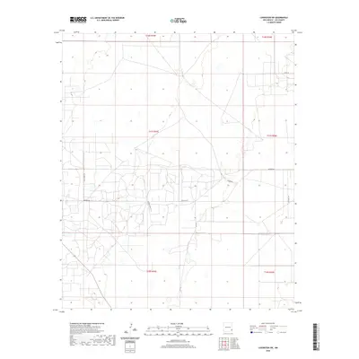
2020 Map of Lovington SW
USGS Topo · Published 2020About this map
The High Plains of Lea County reveal an industrial and ranching landscape characterized by the rectangular geometry of the Public Land Survey System. In this portion of southeastern New Mexico, the terrain is defined by the intersection of local routes like Buckeye Rd and San Andres Ln, which navigate a network of section lines. The presence of Vacuum Complex Ln points to the region's historical and ongoing association with the energy sector, while Lee Ranch Rd reflects the deep-rooted cattle ranching heritage of the Llano Estacado. Small depressions and ephemeral drainages appear near Swamp Rd, providing a contrast to the otherwise arid, structured grid that organizes this corner of the state.
Find a feature on this map
13 named features on this map. Tap any name to fly to it.
Don’t see what you’re looking for? This feature index may not catch every label — zoom into the map to look around manually.
Map Details
Editions of this 2020 Lovington SW Map
This is the sole edition of this map. No revisions or reprints were ever made.
Other maps of this area

1954 · Hobbs
USGS Topo · 1:250,000

1958 · Hobbs
USGS Topo · 1:250,000

1962 · Lovington
USGS Topo · 1:24,000

1962 · Lovington
USGS Topo · 1:62,500

1962 · Buckeye
USGS Topo · 1:62,500

1963 · Monument
USGS Topo · 1:62,500

1963 · Laguna Gatuna
USGS Topo · 1:62,500

1984 · Ironhouse Well
USGS Topo · 1:24,000
1985 · Monument North
USGS Topo · 1:24,000
1985 · Lovington NW
USGS Topo · 1:24,000