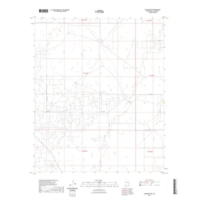
2023 Map of Lovington SW
USGS Topo · Published 2023About this map
High plains terrain defines this section of Lea County, where a grid of rural roads and section lines reveals the organized layout of West New Mexico's ranching and resource country. Central to the area is Buckeye Rd, which serves as a primary east-west artery through the landscape, connecting with north-south routes like San Andres Ln and Co Rd 53. The mapping of these routes alongside local landmarks such as Lee Ranch Rd and the curiously named Swamp Rd reflects the persistence of long-established land divisions and property boundaries in this arid region.
Find a feature on this map
12 named features on this map. Tap any name to fly to it.
Don’t see what you’re looking for? This feature index may not catch every label — zoom into the map to look around manually.
Map Details
Editions of this 2023 Lovington SW Map
This is the sole edition of this map. No revisions or reprints were ever made.
Other maps of this area

1954 · Hobbs
USGS Topo · 1:250,000

1958 · Hobbs
USGS Topo · 1:250,000

1962 · Lovington
USGS Topo · 1:24,000

1962 · Lovington
USGS Topo · 1:62,500

1962 · Buckeye
USGS Topo · 1:62,500

1963 · Monument
USGS Topo · 1:62,500

1963 · Laguna Gatuna
USGS Topo · 1:62,500

1984 · Ironhouse Well
USGS Topo · 1:24,000
1985 · Monument North
USGS Topo · 1:24,000
1985 · Lovington NW
USGS Topo · 1:24,000