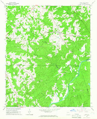
1964 Map of Lowell
USGS Topo · Published 1966About this map
Lowell stands at a crossroads in the northwest corner of Georgia, where family names and rural institutions define the 1960s landscape of Carroll and Heard Counties. The terrain is marked by a high density of country churches and family burial grounds, such as Pentecost Cem, Walker Cem, and Hardegree Cem, reflecting a deeply rooted community structure. The Chattahoochee River carves a path through the southeastern section, meeting the Carroll Co Coweta Co boundary line. In the western portion of the map, Roopville and Star Point serve as local hubs, while historical routes like the Five Notch Road traverse the rolling hills. The distribution of small settlements like Glenloch and numerous congregations including New Lebanon Ch and Mount Lowell Ch indicates a settled agricultural region before the significant suburban expansion of later decades.
Find a feature on this map
39 named features on this map. Tap any name to fly to it.
Don’t see what you’re looking for? This feature index may not catch every label — zoom into the map to look around manually.
Map Details
Editions of this 1964 Lowell Map
2 editions found
Other maps of this area

1889 · Tallapoosa
USGS Topo · 1:125,000

1891 · Marietta
USGS Topo · 1:125,000

1892 · Tallapoosa
USGS Topo · 1:125,000

1895 · Marietta
USGS Topo · 1:125,000

1897 · Marietta
USGS Topo · 1:125,000

1897 · Tallapoosa
USGS Topo · 1:125,000

1899 · Wedowee
USGS Topo · 1:125,000

1901 · Marietta
USGS Topo · 1:125,000

1902 · Wedowee
USGS Topo · 1:125,000

1953 · Atlanta
USGS Topo · 1:250,000