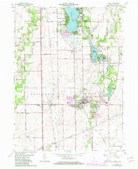
1962 Map of Lowell
USGS Topo · Published 1980About this map
Lowell serves as the primary hub of this southern Lake County landscape, shown here during its late mid-century growth. The town's grid is detailed with civic landmarks like St Edwards Sch and the Athletic Field, while the surrounding prairie is defined by a rigorous network of drainage ditches such as Reeder Ditch and Grizel Ditch. To the north, the recreational and residential development around Cedar Lake and Lake Dalecarlia stands in contrast to the rural farmsteads of West Creek township. Genealogists will find significant value in the documentation of several country burying grounds, including German Cem and West Creek Cem, along with neighborhood anchors like Lake Prairie Sch and Oakland Sch. The presence of the Conrail and Louisville And Nashville rail lines underscores the region's historical dependence on rail transport for its agricultural economy.
Find a feature on this map
56 named features on this map. Tap any name to fly to it.
Don’t see what you’re looking for? This feature index may not catch every label — zoom into the map to look around manually.
Map Details
Editions of this 1962 Lowell Map
2 editions found
Other maps of this area

1922 · Momence
USGS Topo · 1:62,500

1924 · Momence
USGS Topo · 1:62,500

1929 · Dyer
USGS Topo · 1:24,000

1930 · Dyer
USGS Topo · 1:24,000

1949 · Crete
USGS Topo · 1:62,500

1953 · Leroy
USGS Topo · 1:24,000

1953 · St. John
USGS Topo · 1:24,000

1953 · Crown Point
USGS Topo · 1:24,000

1953 · Beecher East
USGS Topo · 1:24,000
1953 · Dyer
USGS Topo · 1:24,000