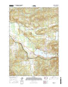
2017 Map of Lowell
USGS Topo · Published 2017About this map
Lowell and Dexter anchor this part of the Lane County landscape where the Middle Fork Willamette River is managed by significant water control projects. The map shows the expansive waters of the Dexter Reservoir and Lookout Point Lake, which have reshaped the valley's original drainage patterns. A trio of historic infrastructure remains prominent, including the Pengra Covered Bridge spanning Fall Creek, the Unity Covered Bridge over Little Fall Cr, and the Lowell Covered Bridge near the town center.
Find a feature on this map
83 named features on this map. Tap any name to fly to it.
Don’t see what you’re looking for? This feature index may not catch every label — zoom into the map to look around manually.
Map Details
Editions of this 2017 Lowell Map
This is the sole edition of this map. No revisions or reprints were ever made.
Other maps of this area

1935 · Lowell
USGS Topo · 1:96,000

1942 · Lowell
USGS Topo · 1:125,000

1950 · Marcola
USGS Topo · 1:62,500

1951 · Leaburg
USGS Topo · 1:62,500

1952 · Marcola
USGS Topo · 1:62,500

1953 · Salem
USGS Topo · 1:250,000

1954 · Salem
USGS Topo · 1:250,000

1955 · Hardesty Mtn
USGS Topo · 1:62,500

1955 · Lowell
USGS Topo · 1:62,500

1958 · Roseburg
USGS Topo · 1:250,000