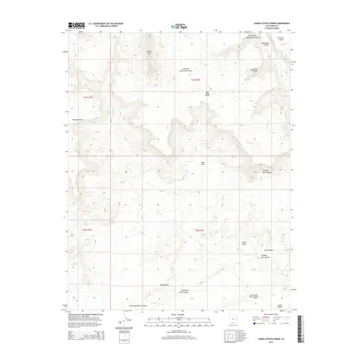
2014 Map of Lower Coyote Spring
USGS Topo · Published 2014About this map
Lower Coyote Spring serves as a vital water source in this high desert landscape, located near the intersection of the Coyote Cr drainage and the sprawling Brigham Plains. This 2014 survey documents a territory defined by intricate erosional features, where the expansive The Rimrocks overlook a network of deep incisions including Big White Rock Canyon and Chimney Rock Canyon. The terrain transitions from broad plateaus like Sit Down Bench and Jack Riggs Bench to dramatic landmarks such as the isolated Chimney Rock and White Rocks. In the northeastern corner, Wahweap Cr cuts through the earth near Cedar Hollow, while the western portion is dominated by the complex tributaries of the Left Fork Chynoweth Canyon and Right Fork Chynoweth Canyon, illustrating the intense geological carving characteristic of southern Kane County.
Find a feature on this map
23 named features on this map. Tap any name to fly to it.
Don’t see what you’re looking for? This feature index may not catch every label — zoom into the map to look around manually.
Map Details
Editions of this 2014 Lower Coyote Spring Map
This is the sole edition of this map. No revisions or reprints were ever made.
Other maps of this area

1886 · Escalante
USGS Topo · 1:250,000

1922 · Upper Last Chance
USGS Topo · 1:63,360

1953 · Nipple Butte
USGS Topo · 1:62,500

1954 · Paria NW
USGS Topo · 1:24,000
1954 · Paria SW
USGS Topo · 1:24,000

1954 · Paria
USGS Topo · 1:62,500

1955 · The Cockscob SW
USGS Topo · 1:24,000

1956 · Escalante
USGS Topo · 1:250,000

1960 · Escalante
USGS Topo · 1:250,000

1964 · Horse Flat
USGS Topo · 1:24,000